
Arctic rivers are modest by global standards. They don't carry the volume of the Amazon or the silt loads of the Ganges. But collectively, they deliver about 11% of the world's river water into an ocean that holds just 1% of the planet's seawater. That imbalance has always made the Arctic Ocean chemically distinct, more influenced by what flows off the land than any other ocean on Earth. Now, as the permafrost beneath those rivers thaws deeper and longer each year, the chemistry of what's flowing in is changing, and the carbon that has been locked underground for tens of thousands of years is entering the water.
A new study led by geoscientist Michael Rawlins at the University of Massachusetts Amherst offers one of the most detailed pictures yet of this transformation. By modeling 44 years of hydrological data across a Wisconsin-sized stretch of Alaska's North Slope at one-kilometer resolution, his team found that runoff is increasing sharply, rivers are carrying growing loads of dissolved organic carbon, and the thawing season is stretching weeks later into the fall than it did just decades ago. The carbon entering these rivers isn't from recent plant decay. It's ancient material, organic matter that accumulated in frozen soil over millennia, now mobilized by warming temperatures and flowing toward the Beaufort Sea.
The findings, published in Global Biogeochemical Cycles in April 2026, point to a feedback loop that most climate models still struggle to account for: the land isn't just warming, it's leaking.
What 44 Years of Data Reveal
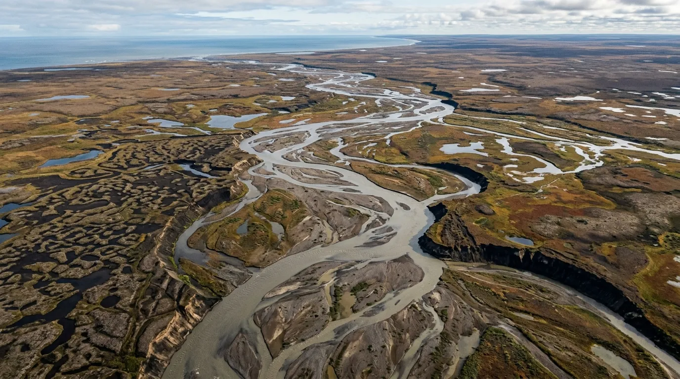
The study covers a region of Alaska's North Slope threaded with more than 300 rivers and streams that drain northward into the Beaufort Sea. Rawlins and his collaborators, Craig T. Connolly and James W. McClelland, built their analysis on the Permafrost Water Balance Model, a tool Rawlins has developed over the past 25 years. The model simulates snow accumulation, melt dynamics, active-layer changes, and, since a 2021 expansion, the movement of dissolved organic carbon through Arctic watersheds.
Each simulation run required approximately 10 continuous days on a supercomputer at the Massachusetts Green High Performance Computing Center. The result is a daily record of river flows and coastal exports from 1980 to 2023, captured at a spatial resolution of one kilometer. "This new study is the first time anyone has captured such a wide area of the Arctic, about the size of Wisconsin, down to the kilometer scale," Rawlins said.
The data tells a consistent story of acceleration. Runoff across the North Slope is rising. Subsurface water flow, the kind that percolates through the active layer of soil above the permafrost, is increasing even faster. And the dissolved organic carbon riding in that water is climbing in lockstep. The model projects that over the next 80 years, overall runoff could increase by up to 25%, with subsurface flow rising by 30%. Southern portions of the study area are trending drier, while northern coastal zones are getting wetter, a redistribution that could alter which rivers carry the most carbon and when.
Ancient Carbon, Modern Rivers
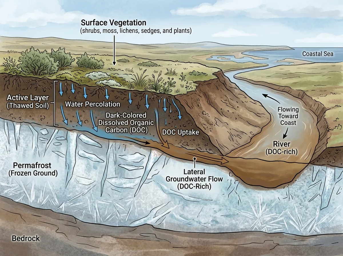
The word "permafrost" is technically a misnomer, as Rawlins points out. The active layer, the topmost portion of soil in permafrost regions, freezes and thaws every year. Plants grow in it during summer. Microbes decompose organic material in it. Water moves through it. What matters for the carbon story is what happens when that active layer deepens, when the boundary between seasonal thaw and permanently frozen ground drops lower than it used to.
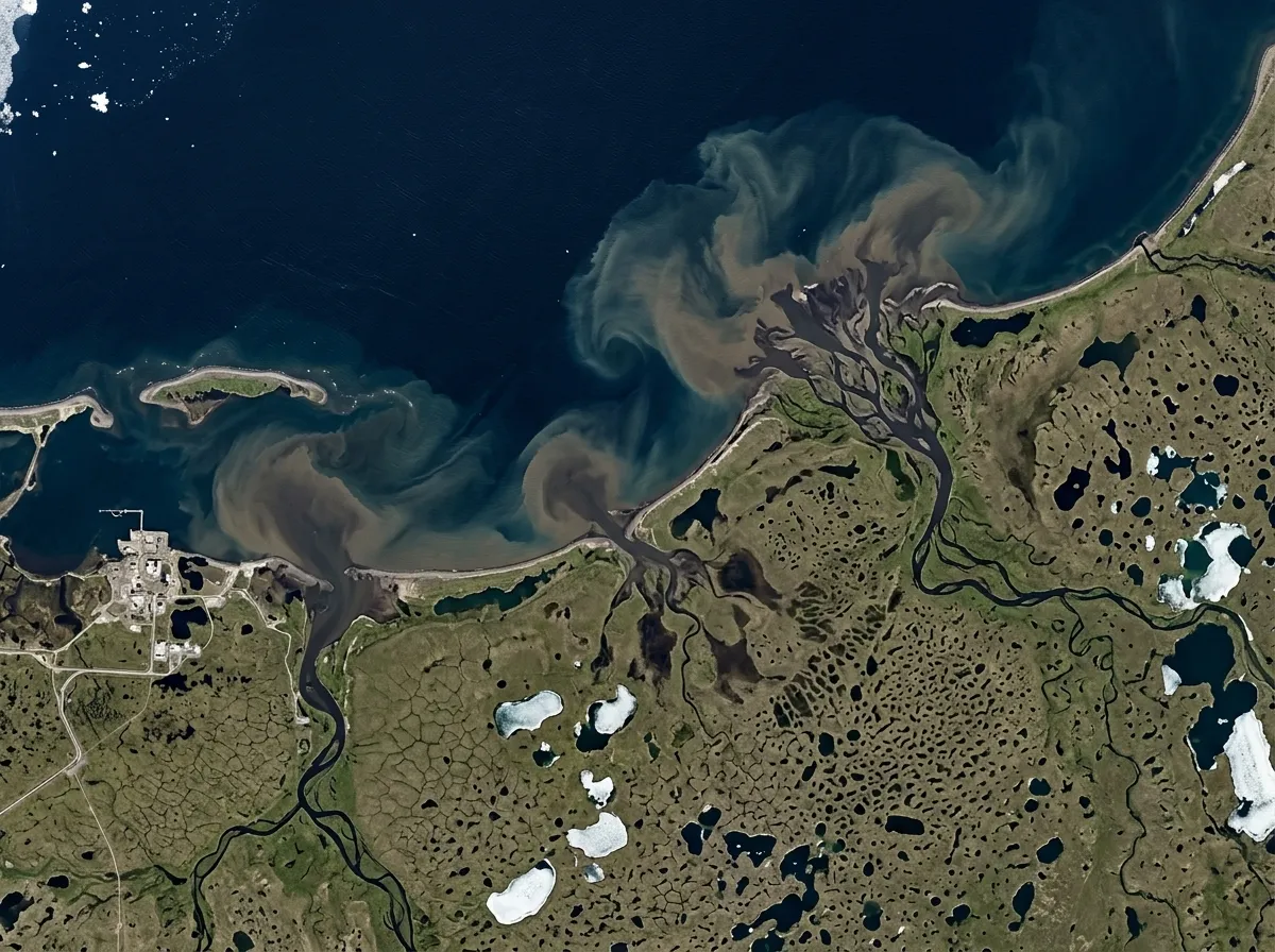
As the active layer expands, groundwater reaches organic material that has been sealed in ice for 10,000 years or more. This material, ancient roots, decomposed plant matter, microbial biomass from eras when Alaska's North Slope was warmer and more vegetated, dissolves into the water and gets carried downstream as dissolved organic carbon, or DOC. Unlike sediment, which is visible and settles out, DOC is invisible in the water column. You can't see it from a satellite. You often can't even see it standing on a riverbank. But it's there, and it's accumulating.
When this DOC-rich water reaches the Beaufort Sea, some of it gets converted to carbon dioxide through microbial and photochemical processes. The Arctic Ocean currently processes roughly 275 million tons of carbon into CO2 annually through these pathways. As permafrost thaw accelerates and rivers deliver more DOC, that number is expected to rise, though by how much remains one of the biggest uncertainties in climate science.
The issue isn't just quantity. It's timing. The study found that the thaw season on the North Slope now extends well into September and October, weeks longer than in previous decades. That extended window means freshwater and carbon are entering the coastal ocean during its transition to winter conditions, when sea ice is forming and marine food webs are shifting between seasonal states. The ecological consequences of changing the chemistry of this transition period are poorly understood, but Rawlins and his team suspect they could cascade through salinity levels, nutrient cycles, and the organisms that depend on them.
Why Northwest Alaska Is Ground Zero
Not all permafrost is created equal, and the study's geographic findings highlight why. The largest increases in dissolved organic carbon export are concentrated in northwest Alaska, not evenly distributed across the North Slope. The reason comes down to geology and topography.
"The farther east you go, the more mountainous it becomes," Rawlins explained. "The soil is rockier and sandier, and far less DOC is mobilized." Northwest Alaska, by contrast, is flat. Its soils are deep and organic-rich, built up over tens of thousands of years by the slow accumulation of plant material in waterlogged, frozen ground. When that ground thaws, the carbon payload per unit of water is significantly higher than in the eastern ranges.
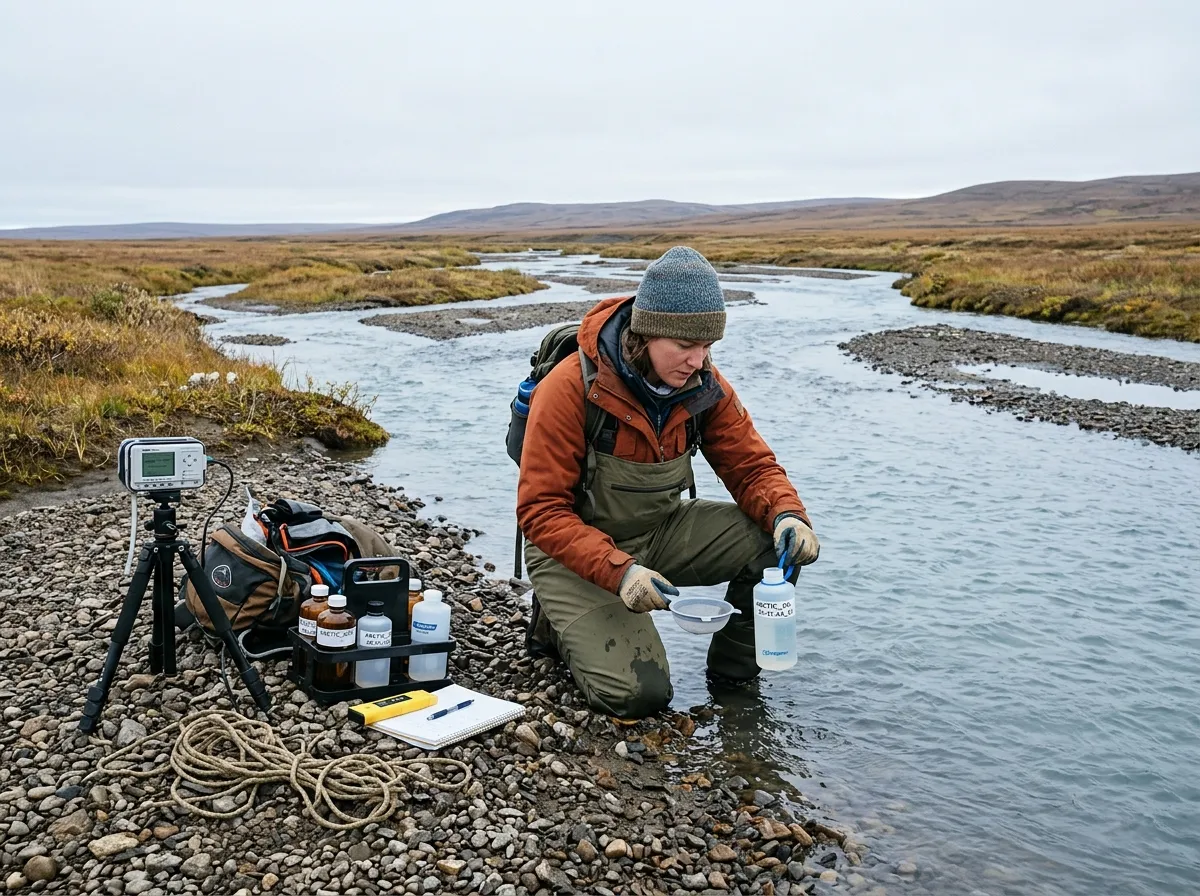
This geographic pattern matters for two reasons. First, it means the carbon release isn't a uniform process that can be modeled with a single regional average. The hotspots are specific and predictable, which is useful for monitoring but also means the problem is concentrated in areas where observation stations are sparse. "There are nowhere near enough river sample measurements to quantify inputs to estuaries along the entire Alaskan North Slope," Rawlins noted. The model fills that gap, but models need validation, and validation requires sensors in the right rivers.
Second, the flat terrain of northwest Alaska is also where thermokarst activity, the collapse of ground as underlying ice melts, is most pronounced. Thermokarst lakes and slumps expose even deeper permafrost to warm air and water, creating localized carbon release events that can dwarf the steady background signal from active-layer deepening. The study's model captures the broad trend, but these episodic events remain difficult to simulate at any resolution.
From Riverbeds to the Global Carbon Budget
The Arctic carbon cycle has a reputation problem in climate modeling. Most global climate models treat permafrost carbon as a slow-release reservoir, something that will matter over centuries but doesn't need detailed treatment in decadal projections. Rawlins's work, along with a growing body of research on Arctic ecosystem changes, challenges that assumption.
The feedback mechanism works like this: warming temperatures thaw permafrost, which releases carbon into rivers, which deliver it to the ocean, where microbial and photochemical processes convert some of it to CO2, which enters the atmosphere and contributes to further warming. Each step has its own uncertainties, its own timescales, its own geographic variability. But the direction is consistent, and the Rawlins study provides hard evidence that at least the first two steps, thaw and riverine transport, are already accelerating.
What makes the land-to-ocean connection particularly tricky is that it crosses disciplinary boundaries. Hydrologists study river flow. Soil scientists study permafrost. Marine chemists study ocean carbon. Atmospheric modelers study CO2 fluxes. The full chain from frozen soil to atmospheric greenhouse gas requires all of these fields working in concert, and that coordination has been slow to develop. "We desperately need more of these land-to-ocean connection studies," Rawlins said. His team's work demonstrates what becomes visible when you bridge those gaps: a coherent picture of a system that is changing faster than most of its individual components would suggest.
The 275-million-ton annual carbon conversion figure for the Arctic Ocean comes with an important caveat. Not all of that carbon originated in permafrost. Some comes from contemporary plant material, some from coastal erosion, some from marine sources. Disentangling the ancient permafrost contribution from these other sources is an active area of research, and the answer matters enormously for climate projections. If the permafrost fraction is growing, it means the Earth's warming is unlocking carbon reserves that took millennia to accumulate, on a timescale of decades.
The Deeper Question
The Rawlins study answers a specific question with unusual precision: how much freshwater and dissolved organic carbon is flowing from Alaska's North Slope into the Beaufort Sea, and how has that changed over 44 years? The answer, more water, more carbon, longer seasons, with acceleration concentrated in the organic-rich flatlands of the northwest, is clear and well-supported.
But the deeper question it raises is one that climate science hasn't fully reckoned with. We tend to think of carbon reservoirs as either active (the atmosphere, oceans, living biomass) or locked away (fossil fuels, permafrost, deep-sea sediments). The boundary between those categories is supposed to shift slowly, over geological timescales. What the Arctic is showing us is that the boundary can shift within a human lifetime, that carbon frozen since the last ice age can enter the active cycle within decades, carried by the same rivers that have always drained the tundra.
The next frontier for this research involves extending the kilometer-scale modeling approach to the entire Arctic permafrost region, roughly 22.5 million square kilometers across Alaska, Canada, Scandinavia, and Siberia. Rawlins's team has already begun that work, having applied the expanded Permafrost Water Balance Model across the full circumpolar zone in 2024. The challenge is computational: each regional simulation requires days of supercomputer time, and the full Arctic at one-kilometer resolution remains at the edge of what current infrastructure can handle.
What we know already is enough to change how we think about the Arctic's role in the climate system. It's not a passive victim of warming, a place where ice melts and sea levels rise. It's an active participant, a region that absorbs heat and returns carbon, amplifying the very process that's transforming it. The rivers of Alaska's North Slope, carrying their invisible loads of ancient carbon toward the sea, are one of the clearest expressions of that feedback loop we've measured so far.
Sources
- A Wisconsin-sized chunk of Alaskan permafrost is thawing; Arctic and global climate may never be the same - University of Massachusetts Amherst
- A massive arctic thaw is unleashing carbon frozen for thousands of years - ScienceDaily
- Alaska's thawing permafrost is flushing ancient carbon into rivers - Earth.com
- Rawlins, M.A., Connolly, C.T., McClelland, J.W. "Hydrological Cycle Intensification and Permafrost Thaw Drive Increased Freshwater and Organic Carbon Inputs to Northern Alaska Estuaries." Global Biogeochemical Cycles, 2026; 40(4). DOI: 10.1029/2025GB008822