
In April 1913, a team of seven Americans stood on the frozen expanse north of Greenland and stared at the horizon. They had traveled thousands of miles, endured blizzards and frostbite, and spent months hauling supplies across Arctic ice to reach this point. Their destination was Crocker Land, a vast Arctic landmass that the famed explorer Robert Peary had reported sighting in 1906. Peary described it as unmistakable: land, snow-capped mountains stretching across the northwestern horizon. He even named it, after one of his financial backers, George Crocker.
The expedition leader, Donald MacMillan, scanned the distance and saw what appeared to be a huge island on the northwestern horizon. But Piugaattoq, an Inuk hunter with twenty years of experience in the region, shook his head. He called it poo-jok: mist. It was a mirage, a refraction of light across the ice that created the convincing illusion of distant land. Crocker Land did not exist. It had never existed. And the expedition to find it would end not in discovery but in murder, when expedition member Fitzhugh Green shot Piugaattoq in the back during their return journey, a killing for which Green was never charged.
The Crocker Land Expedition is the most dramatic example of a phenomenon that threads through centuries of cartographic history: phantom islands, places that appeared on authoritative maps, were treated as geographic fact, shaped exploration and geopolitics, and were eventually proven to have never existed at all.
The Island That Wouldn't Die
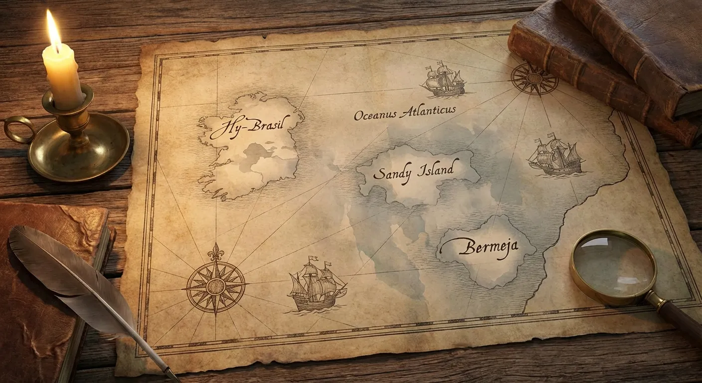
Of all phantom islands, Hy-Brasil may be the most persistent. First appearing on nautical charts around 1325, this circular island was depicted west of Ireland, usually with a channel running through its center. It appeared on maps for over five hundred years, its position shifting slightly with each new edition but its existence never questioned. Cartographers drew it with the same confidence they applied to known landmasses. Sailors reported sighting it. Expeditions were launched to find it.
Hy-Brasil (not related to the country of Brazil, which was named for the brazilwood tree) appears to have originated from Celtic mythology, where it was described as a paradise shrouded in mist that materialized only once every seven years. But the transition from legend to cartographic "fact" happened gradually, as mapmakers copied from earlier maps without verifying the underlying data. Each reproduction made the island more authoritative. By the time the Catalan Atlas of 1375 included it, Hy-Brasil was treated as established geography.
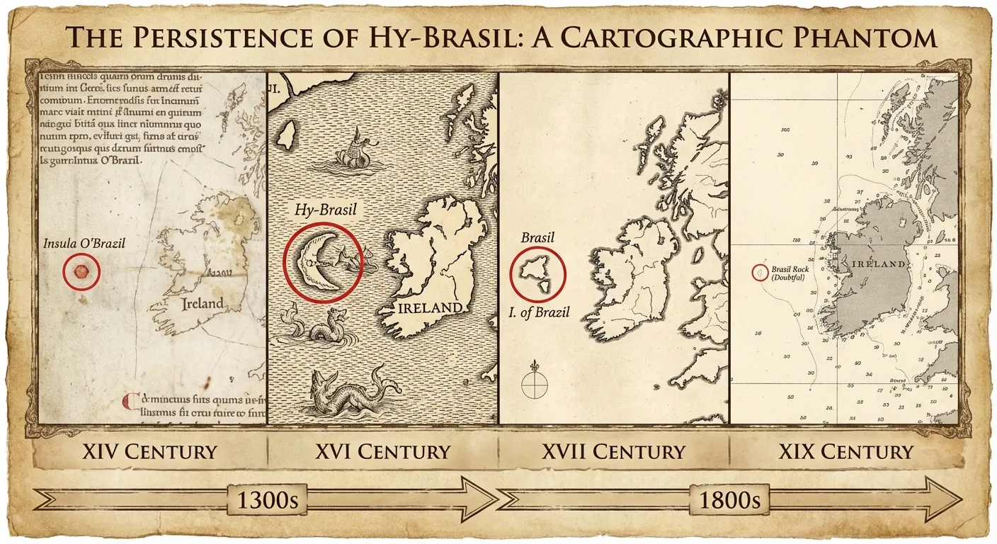
The island wasn't removed from British Admiralty charts until 1865. That means Hy-Brasil was considered a real place, by the world's most authoritative maritime cartographic authority, for approximately five centuries after its first appearance on a map. Its removal wasn't prompted by a dramatic expedition or a scientific revelation. It was simply the accumulation of enough negative evidence: enough ships passing through the coordinates without finding land, enough surveys covering the area without detecting a bottom. The island was erased not by discovery but by the slow, undramatic weight of absence.
Sandy Island and the Digital Ghost
If Hy-Brasil represents the analog era of phantom islands, Sandy Island represents the digital one. This substantial landmass, roughly the size of Manhattan, appeared on maps between Australia and New Caledonia in the Coral Sea. It was present on Google Maps and Google Earth. It appeared in the authoritative World Vector Shoreline Database, which underpins nautical charts used by navies worldwide. It was included in the Times Atlas of the World.
In November 2012, a team of Australian scientists aboard the research vessel R/V Southern Surveyor sailed to Sandy Island's coordinates and found nothing but open ocean more than 1,300 meters deep. The island, which had appeared on maps since at least the late 19th century, was removed from Google Maps on November 26, 2012.
The investigation into how Sandy Island persisted reveals the mechanics of error propagation in the digital age. The island appears to have originated from a sighting by the whaling ship Velocity in 1876, which reported land at approximately the correct coordinates. This observation was entered into hydrographic records, from which it was copied into successive chart editions, then digitized into electronic databases, then imported into Google's mapping platform. At no point in this chain of transmission did anyone return to the original location to verify the claim. Each system trusted the previous one, and the error cascaded forward with increasing authority.
Bermeja: The Island Worth Billions
Not all phantom islands are merely cartographic curiosities. Some carry geopolitical weight. Bermeja, a small island first described by Spanish cartographer Alonso de Santa Cruz in 1539, was charted approximately 110 kilometers northeast of Mexico's Yucatan Peninsula. It appeared on maps for centuries. And when Mexico and the United States entered negotiations in the late 2000s over maritime boundaries and oil drilling rights in the Gulf of Mexico, Bermeja's existence became critically important.
Under international maritime law, islands extend a nation's exclusive economic zone. If Bermeja existed, Mexico's maritime boundary would extend further north into the Gulf, encompassing oil-rich areas known as the "Doughnut Holes" (Hoyos de Dona). The stakes were measured in billions of dollars of petroleum revenue.

In 2009, the Mexican Navy conducted a comprehensive survey of the coordinates where Bermeja should have been. They found nothing. No island, no seamount, no submerged landmass. The island that had appeared on maps for nearly five centuries had, apparently, never been there at all. Without Bermeja, Mexico's maritime boundary remained further south, and the country lost access to potentially billions of dollars in oil reserves.
The disappearance prompted conspiracy theories in the Mexican senate, with several legislators from the National Action Party suggesting the United States might have deliberately destroyed the island to secure an advantage in Gulf oil negotiations. No evidence supported this claim, but the political intensity of the response illustrated something important: phantom islands are not merely abstract cartographic errors. They have real consequences when they intersect with sovereignty, resources, and power.
The Epistemology of Nonexistent Places
The persistence of phantom islands across centuries of mapmaking raises a question that extends far beyond cartography: how do authority-based knowledge systems propagate error?
The mechanism is consistent across cases. An initial observation (sometimes genuine, sometimes fabricated, sometimes a misinterpretation of natural phenomena like mirages or fog banks) enters an authoritative record. Subsequent mapmakers copy from earlier maps rather than conducting independent verification. Each act of copying adds a layer of apparent confirmation. After several generations of reproduction, the island appears in multiple "independent" sources, all of which ultimately trace back to the single original claim.
This is the same structure that produces what researchers call citation cascades in academic publishing. A study published in Research Integrity and Peer Review found that only about 20 percent of authors actually read the original paper they cite. The rest cite secondary sources, which may themselves be citing other secondary sources, creating chains of apparent authority that can propagate errors indefinitely. A retracted finding can continue to influence research for years after retraction, because its claims have been absorbed into the citation network through layers of secondary reproduction.
The digital age has introduced a specific variant of this problem: citogenesis. The term, coined by the webcomic xkcd, describes the cycle in which an unsourced claim appears on Wikipedia, is then repeated by a journalist or researcher who treats Wikipedia as background reference, and the resulting publication is then added as a citation to the original Wikipedia article, closing a loop of circular validation. A 2019 investigation by Slate documented multiple cases of this phenomenon, where claims with no original source acquired apparent authority through precisely this mechanism.
Mirages, Mistakes, and Motivated Reasoning
The origins of phantom islands fall into several categories, and understanding these categories reveals the full range of ways that false geographic knowledge can be generated.
Some phantom islands were honest misidentifications. Arctic and oceanic environments produce atmospheric conditions that bend light in dramatic ways, creating convincing optical illusions that have shaped human understanding across cultures. Fata morgana mirages can project images of distant coastlines, icebergs, or cloud formations that look indistinguishable from real land. Peary's sighting of Crocker Land was almost certainly a fata morgana, a mirage so convincing that an experienced Arctic explorer mistook it for a mountain range.
Others were deliberate fabrications. Peary may have invented Crocker Land to justify continued funding from George Crocker, a pattern consistent with the financial pressures that drove many exploration-era claims. Some cartographers inserted fictional islands as copyright traps, a way to detect unauthorized copying of their maps (the cartographic equivalent of a dictionary's deliberate false entries).
Still others were the product of motivated reasoning. The search for lost cities and archaeological mysteries shows how the desire to find something can shape what explorers report seeing. Bermeja may have been a genuine navigational error that persisted because no one had reason to question it until oil rights made its existence economically significant.
What This Means
Phantom islands are specific historical curiosities, but the pattern they illustrate is universal. Any knowledge system that relies on authority rather than independent verification is vulnerable to the same failure mode: an initial error, reproduced across generations of copies, accumulating apparent credibility with each reproduction until the false claim is treated as established fact.
The modern information ecosystem is, in many ways, more susceptible to this pattern than historical cartography was. Maps, at least, could eventually be checked against physical reality: someone could sail to the coordinates and look. But claims about abstractions, statistical findings, historical interpretations, scientific mechanisms, can circulate through citation networks for decades without anyone replicating the original work. The structures that propagate phantom islands (authority-based transmission, lack of independent verification, circular validation) are the same structures that propagate phantom facts.
The most unsettling lesson of phantom islands may be about what disappears when they do. Sandy Island was removed from Google Maps in a single day. Bermeja was declared nonexistent after a single Navy survey. Hy-Brasil vanished from Admiralty charts with a quiet editorial decision. In each case, the correction was undramatic. No one announced that an island had been proven false. The island simply stopped appearing. The centuries of maps that had included it remained on shelves and in archives, their errors uncorrected, their authority intact for anyone who consults them without checking the latest edition.
Knowledge, it turns out, is more like a map than a photograph: not a record of what exists, but a model that includes whatever its makers believed existed, for reasons that may have nothing to do with the territory itself.