
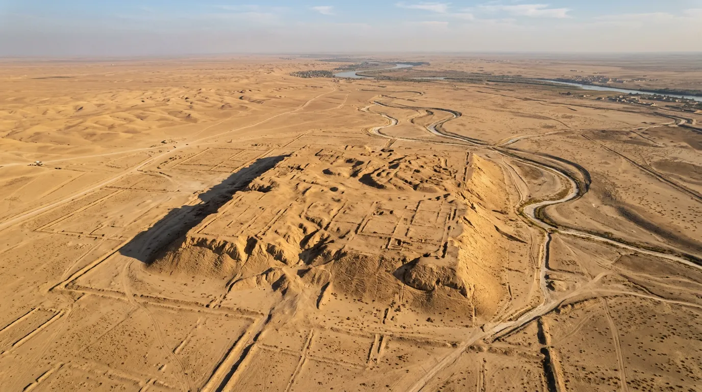
For decades, soldiers dug foxholes and built defensive positions on a flat-topped mound called Jebel Khayyaber in southern Iraq, unaware they were fortifying one of the ancient world's largest port cities. During the Iran-Iraq War of the 1980s, the site absorbed shelling, trench construction, and military earthworks while the city beneath it, founded more than 2,300 years earlier during Alexander the Great's eastward campaigns, went entirely unrecognized. Armies literally fought on top of a place that had once controlled nearly all maritime trade flowing into Mesopotamia from the Indian Ocean.
The city was Alexandria on the Tigris, later known as Charax Spasinou. Between roughly 300 BCE and 300 CE, it was one of the most commercially important cities in the ancient Near East, funneling goods from India, Central Asia, and the Arabian Peninsula northward along the Tigris to the great capitals of Seleucia and Ctesiphon. It appeared in ancient texts, on trade records, and even on coins. Yet its physical location remained uncertain for centuries, and modern conflict kept researchers away for generations. Now, using drone surveys, geophysical scanning, and careful surface archaeology, an international team led by Jaafar Jotheri of the University of Al-Qadisiyah has confirmed the identification and begun mapping what was once one of the busiest harbors in the ancient world.
A Port Built Because the Sea Moved
Alexander the Great founded or refounded dozens of cities across his empire, many of them named Alexandria. Most were military garrisons or administrative outposts positioned along strategic routes. Alexandria on the Tigris was different. It was built to solve a specific geographic problem: the Persian Gulf's northern coastline was retreating.
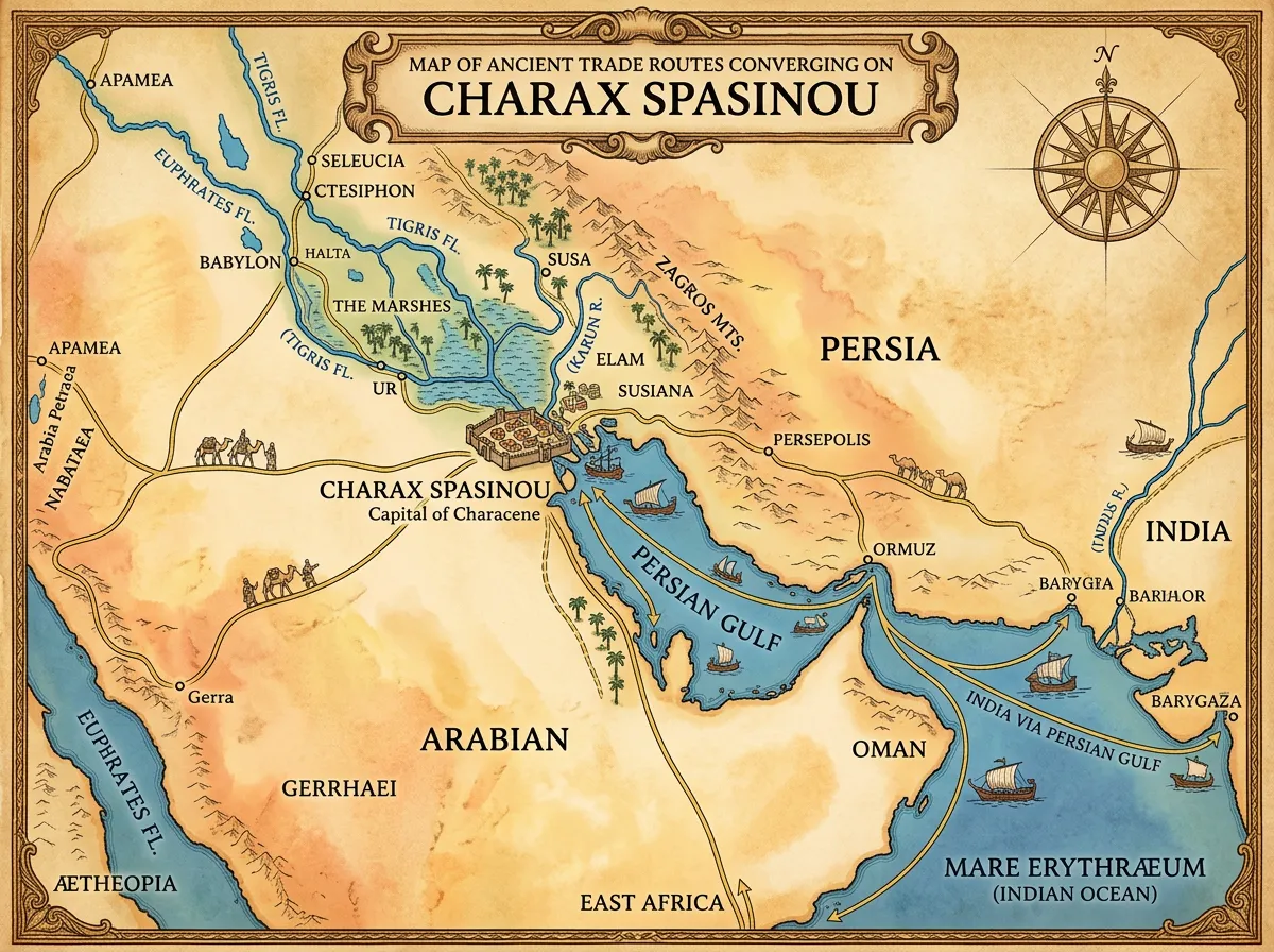
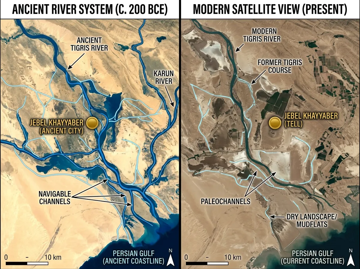
By the late 4th century BCE, millennia of sediment carried by the Tigris, Euphrates, and Karun rivers had extended the southern Mesopotamian shoreline dozens of kilometers further into the Gulf. Older port cities that had once sat at the water's edge were now stranded inland, their harbors choked with alluvial deposits. The region needed a new port, one positioned at the current confluence of the Tigris and Karun rivers where ships could still navigate. Alexander, or more likely his immediate successors in the Seleucid dynasty, established the city precisely at this junction.
The location was strategically brilliant. Sitting where the Karun joined the Tigris near the head of the Persian Gulf, the city commanded the choke point through which virtually all seaborne trade had to pass before reaching inland Mesopotamia. Ships arriving from India, the Arabian coast, or East Africa would discharge their cargoes here, and goods would then travel by river barge northward to the great consumer markets of the interior. The city didn't just participate in long-distance trade; it was the gate through which trade entered the region.
Over the following centuries, the settlement grew under various rulers. The Seleucids maintained it, and under a local dynasty in the 2nd century BCE, it was renamed Charax Spasinou after its ruler Hyspaosines. By the Roman period, the geographer Pliny the Elder described it as an important commercial center. Its coins circulated widely, and its merchants appear in records from across the Indian Ocean trading network.
Clues from the Sky, Decades Apart
The first modern hint that Jebel Khayyaber might be Charax Spasinou came not from excavation but from the air. In the 1960s, British researcher John Hansman studied aerial photographs taken by the Royal Air Force during earlier decades of British involvement in Iraq. The images showed settlement outlines and geometric features on the mound that were consistent with a large ancient city. Hansman published his identification, linking the site to the ancient literary descriptions of Charax Spasinou.
But the identification could not be tested on the ground. The region descended into a series of conflicts that made archaeological fieldwork impossible. The Iran-Iraq War (1980 to 1988) turned the area into a combat zone, and Jebel Khayyaber itself was used as a military position. The Gulf War followed, then sanctions, then the 2003 invasion and its aftermath. For roughly half a century, the site was inaccessible to researchers.
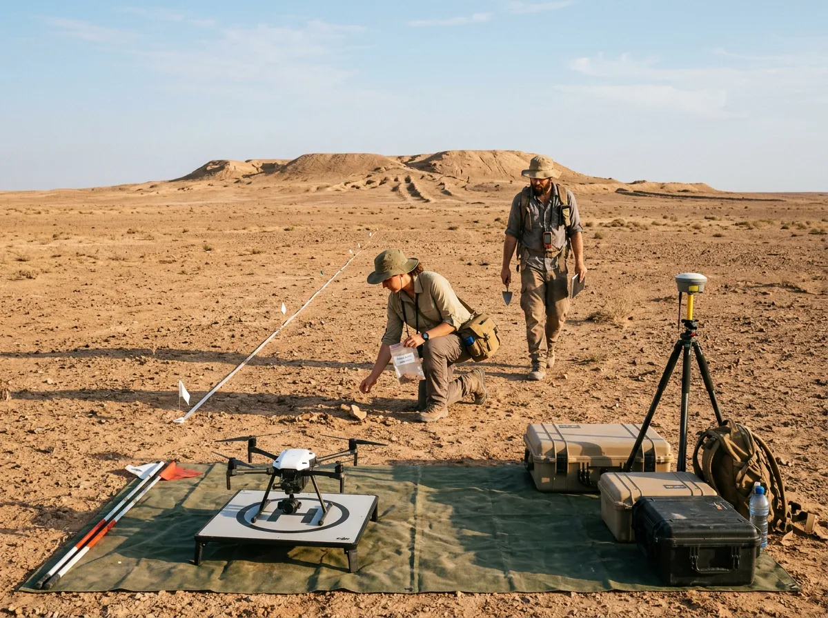
Foreign archaeological teams began returning to southern Iraq in 2014, as security conditions gradually improved. Jotheri, whose expertise lies in geoarchaeology and the study of ancient river systems, recognized that the site could finally be investigated with modern methods. But the decades of military use had left the mound scarred with trenches, earthworks, and unexploded ordnance. Traditional excavation was impractical and dangerous.
The team turned instead to non-invasive techniques. Drone surveys captured high-resolution imagery of the site from multiple altitudes and angles, revealing surface features invisible from the ground. Surface walks covering hundreds of kilometers documented pottery sherds, building materials, and other artifacts scattered across the mound and surrounding terrain. Geophysical scanning, which uses instruments to detect buried structures without digging, mapped subsurface features that confirmed the presence of large-scale architecture consistent with a major urban center.
What the Surface Revealed
The combined data from drone imagery, surface collection, and geophysical scans painted a picture of a city far larger than a minor outpost. The settlement mound covers a substantial area, and the distribution of surface artifacts suggests dense urban occupation extending over several centuries. Pottery fragments recovered from the surface span a range of periods from the Seleucid era through the Parthian period, consistent with the city's known occupation dates.
Jotheri's research, published in the journal Antiquity, also drew on his broader work studying the ancient hydrology of southern Iraq. Understanding where rivers flowed in antiquity is essential for identifying ancient settlements in this region, because Mesopotamian cities depended on river access for water, transportation, and trade. By reconstructing the ancient courses of the Tigris and Karun rivers using satellite imagery and geological fieldwork, Jotheri was able to demonstrate that the Jebel Khayyaber site originally sat at the confluence of these two waterways, exactly where ancient sources placed Charax Spasinou.
"The site's position on the ancient river network matches the historical descriptions precisely," Jotheri explained, noting that the convergence of textual, geographic, and material evidence makes the identification robust even without large-scale excavation. The approach reflects a broader trend in Near Eastern archaeology, where conflict, landmines, and political instability often make traditional dig methods impossible. Researchers have learned to extract remarkable amounts of information from surface evidence and remote sensing, and the Charax Spasinou study is a clear example of what those methods can achieve.
The surface finds also included fragments of imported pottery and materials consistent with long-distance trade connections, which fits the literary description of the city as a commercial hub. Ancient writers described merchants from India, Palmyra, and the Arabian Peninsula doing business at Charax Spasinou, and the material evidence suggests a cosmopolitan settlement engaged with trading partners across thousands of kilometers.
Why the City Died
The decline and eventual abandonment of Charax Spasinou was caused by the same geological forces that created it. The rivers that made the city viable as a port continued depositing sediment, pushing the coastline of the Persian Gulf ever further south. At the same time, the Tigris River itself gradually shifted westward, altering its main channel and cutting the city off from the reliable water access it needed.
By the 3rd century CE, the combination of river migration and continued sedimentation had made the site untenable as a port. Ships could no longer reach it easily, and the commercial networks that had sustained the city for 600 years rerouted to more accessible locations. The city was abandoned, and over the following centuries, wind-blown sand and alluvial deposits buried its remains.
This pattern of rise and decline driven by river dynamics is common across Mesopotamian history. Cities that thrived for centuries could be rendered obsolete within a few generations if their river shifted course. The ancient Sumerian city of Ur, located roughly 200 kilometers to the northwest, suffered a similar fate when the Euphrates changed its path. Understanding this dynamic is central to understanding how ancient civilizations adapted to their environments, and it helps explain why the Mesopotamian floodplain is littered with abandoned settlement mounds.
What makes Charax Spasinou's story particularly striking is the scale of what was lost. This was not a small farming village overtaken by a shifting riverbank. It was one of the largest and most commercially significant cities in the region, handling a volume of trade that connected three continents. Its disappearance from the physical terrain, while its name persisted in ancient texts, created a puzzle that took modern technology to solve.
The Archaeology of Inaccessible Places
The identification of Charax Spasinou raises a question that extends well beyond this single site: how many ancient cities of comparable significance remain unexamined because they sit in conflict zones, restricted military areas, or politically unstable regions?
Southern Iraq alone contains thousands of archaeological sites, many of them unexcavated and some of them completely undocumented. The alluvial plains of the Tigris and Euphrates, where some of humanity's earliest cities were built, have been affected by conflicts, dam construction, agricultural development, and looting for over a century. Each of these forces destroys archaeological context that can never be recovered. The military trenches dug into Jebel Khayyaber during the Iran-Iraq War damaged deposits that had been undisturbed for two millennia. Similar damage has occurred at sites across the region.
The non-invasive methods used at Charax Spasinou offer a partial solution. Drone surveys, satellite imagery, geophysical scanning, and systematic surface collection can document sites without excavation, preserving fragile deposits while still generating useful data. These techniques have transformed archaeology in conflict-affected regions over the past decade, enabling researchers to work in areas where digging would be dangerous, politically impossible, or both. The use of advanced technology to locate ancient sites has become increasingly common as the tools grow cheaper and more precise.
But remote sensing has clear limitations. It can identify the presence and extent of buried structures, but it cannot recover the organic materials, inscriptions, small finds, and stratigraphic sequences that provide the detailed information archaeologists need to reconstruct daily life. At Charax Spasinou, we now know where the city is and approximately how large it was. We know far less about how its inhabitants lived, what they ate, what languages they spoke at home, or how the city's diverse commercial population organized itself socially. Those questions will require excavation, which in turn requires stable security conditions and sustained funding.
An Original Assessment: Trade Cities and Historical Memory
The story of Charax Spasinou illuminates a broader pattern in how we remember the ancient world. The cities that dominate historical memory tend to be political and cultural capitals: Athens, Rome, Babylon, Alexandria in Egypt. Commercial cities, the places where actual economic life happened, receive far less attention despite their enormous historical importance. Charax Spasinou handled trade volumes that connected the Mediterranean world to India and East Africa for six centuries, yet it barely appears in popular accounts of the ancient world.
This blind spot has consequences for how we understand ancient economies. Textbook accounts of Hellenistic and Parthian-era trade often describe goods "flowing" between East and West as though commerce happened automatically, without specific infrastructure or specific places. The reality was that trade required ports, warehouses, currency exchange, legal systems for resolving disputes between merchants from different cultures, and physical security for valuable cargoes. Charax Spasinou provided all of these things. It was the physical infrastructure that made "Silk Road" trade possible at its western terminus, and its decline forced the entire regional trading system to reorganize.
The city also complicates simple narratives about Alexander's legacy. Alexander is typically remembered for his military conquests and the spread of Greek culture. But the Alexandrias he founded were economic engines as much as cultural outposts. They were positioned at trade choke points, river crossings, and caravan junctions, and their commercial functions often outlasted their Hellenistic cultural character by centuries. Charax Spasinou was refounded by a local ruler, renamed, and continued to thrive under Parthian authority long after Greek cultural influence had faded. The city's commercial logic was more durable than any particular empire's political control, a pattern visible at other ancient sites shaped by evolving lunar and geological forces over long timescales.
Recognizing trade cities as historically significant in their own right, rather than as footnotes to imperial narratives, would give us a more accurate picture of how the ancient world actually functioned. The merchants of Charax Spasinou probably had more daily contact with India than with Athens, and the goods they handled affected more lives than most military campaigns. That their city lay hidden under a military installation for decades, unrecognized and unprotected, says something about which parts of the past we choose to remember and which we allow to disappear.
The Bigger Picture
The identification of Charax Spasinou at Jebel Khayyaber closes a gap that has persisted since antiquity. Ancient writers knew the city existed. Modern researchers suspected where it was. But confirmation required the convergence of improved security conditions, non-invasive archaeological techniques, and Jotheri's detailed reconstruction of the region's ancient river systems. The result is the recovery of a place that, at its height, was one of the most commercially significant cities between the Mediterranean and India.
What the site still conceals is almost certainly more revealing than what the surface surveys have documented so far. Beneath the military scars and wind-blown sand, the remains of warehouses, docks, residential quarters, and religious buildings likely survive. The pottery fragments and trade goods visible on the surface hint at a cosmopolitan city where Mesopotamian, Indian, Arabian, and Central Asian material cultures mixed. Excavation, when it becomes possible, could reveal the physical infrastructure of ancient long-distance trade in extraordinary detail.
For now, the study published in Antiquity adds Charax Spasinou to the growing list of major ancient sites documented through remote sensing in post-conflict regions. Each addition reminds us that the ancient world was larger, more connected, and more commercially sophisticated than traditional narratives suggest. One of Alexander's forgotten cities lay under Iraqi desert for 23 centuries, waiting for the wars above it to stop and the rivers around it to be mapped. The wars paused. The rivers were mapped. And the city, at last, has been found.
Sources
- Jaafar Jotheri et al., "Alexandria/Charax Spasinou: Locating One of the Great Cities of the Ancient World" - Antiquity, Cambridge University Press
- John Hansman, "Charax and the Karkheh" - Iranica Antiqua, 1967 (original site identification from RAF aerial photographs)
- Pliny the Elder, Natural History, Book VI (ancient description of Charax Spasinou as a commercial center)
- Potts, D.T., "The Arabian Gulf in Antiquity" - Oxford University Press (comprehensive study of Gulf trade networks and sedimentation patterns)