
In 324 BC, one year before his death, Alexander the Great stood at the confluence of the Tigris and Karun rivers in southern Mesopotamia and ordered a city built. He settled Macedonian veterans there, gave their quarter a name from home (Pella, after Macedonia's capital), and positioned the settlement exactly where river traffic from Babylon and the north would meet maritime trade routes running through the Persian Gulf to India. It was the last major city he would ever found. Within a few centuries, the Tigris shifted course, the Persian Gulf retreated southward, and the city was swallowed by the Iraqi desert. For nearly two thousand years, nobody knew exactly where it was.
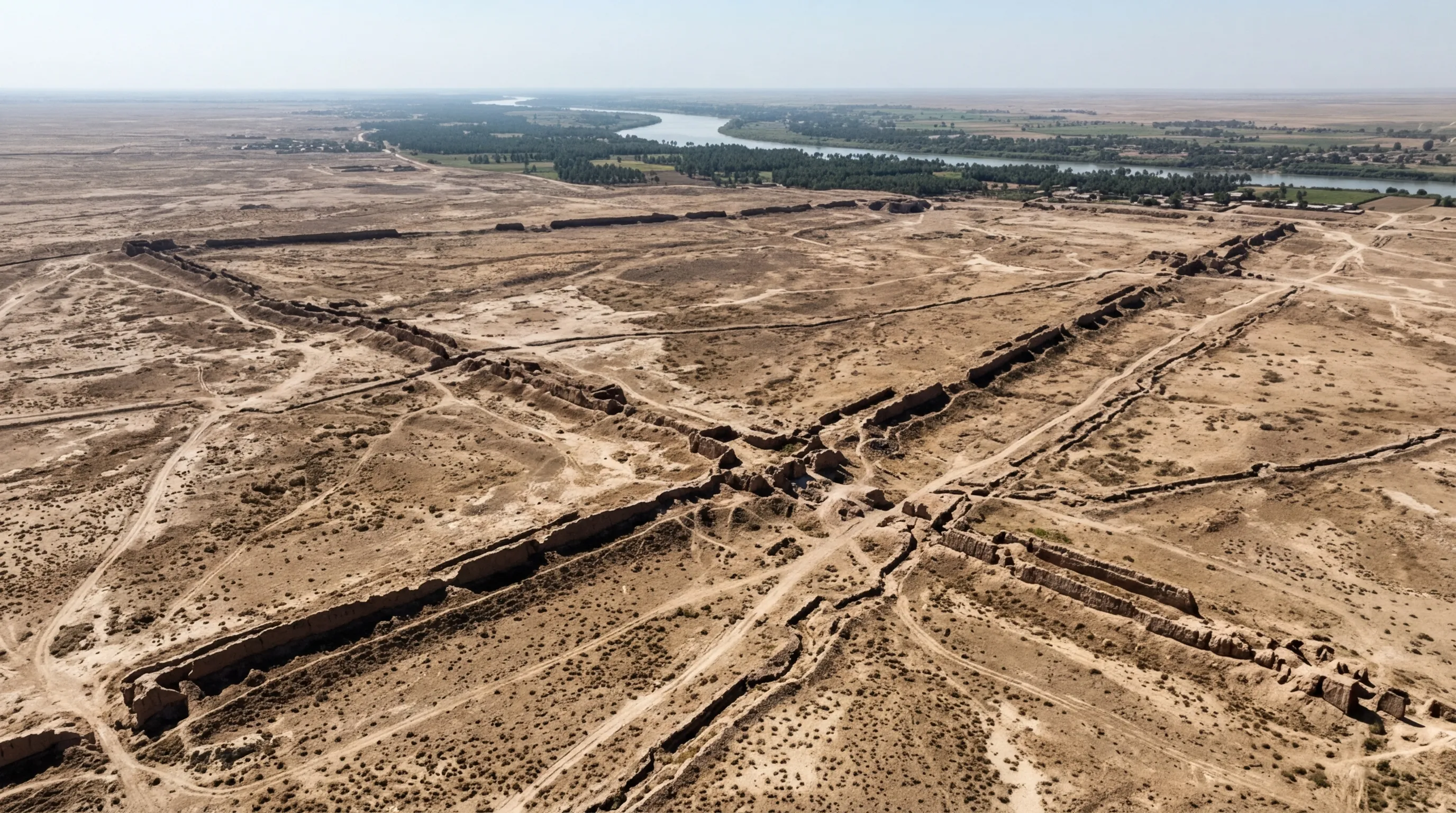
Now they do. A team led by Professor Stefan Hauser of the University of Konstanz has confirmed that the sprawling ruins at Jebel Khayyaber in southern Iraq, just 15 kilometers from the Iranian border, are the remains of Alexander's Alexandria on the Tigris, later known as Charax Spasinou. The site covers approximately 2.5 square miles, with mudbrick ramparts still rising up to eight meters above the flat alluvial plain. Geophysical surveys have revealed a gridded city plan with residential blocks larger than those found at Seleucia or even Alexandria in Egypt. "We realized that we had really found the equivalent of the famous Egyptian city," Hauser said.
Then, in March 2026, the excavations were shut down again. This time by a different war.
A City Found, Lost, and Found Again
The ruins first appeared in Royal Air Force aerial photographs taken during the 1960s. A British researcher named John Hansman studied the images and identified the massive settlement outlines, connecting them to ancient descriptions of a great port city at the head of the Persian Gulf. His identification was persuasive, but it remained unverified. The Iran-Iraq War (1980-1988) turned the site into a military fortress. Iraqi engineers arrived in 1984 and punched approximately 45 gaps through the ancient ramparts so tanks could be positioned inside. At least 199 infantry dugouts and 212 vehicle emplacements were dug into the five-square-kilometer site. Helmets, buttons, and bullet casings mixed with Parthian coins on the surface.
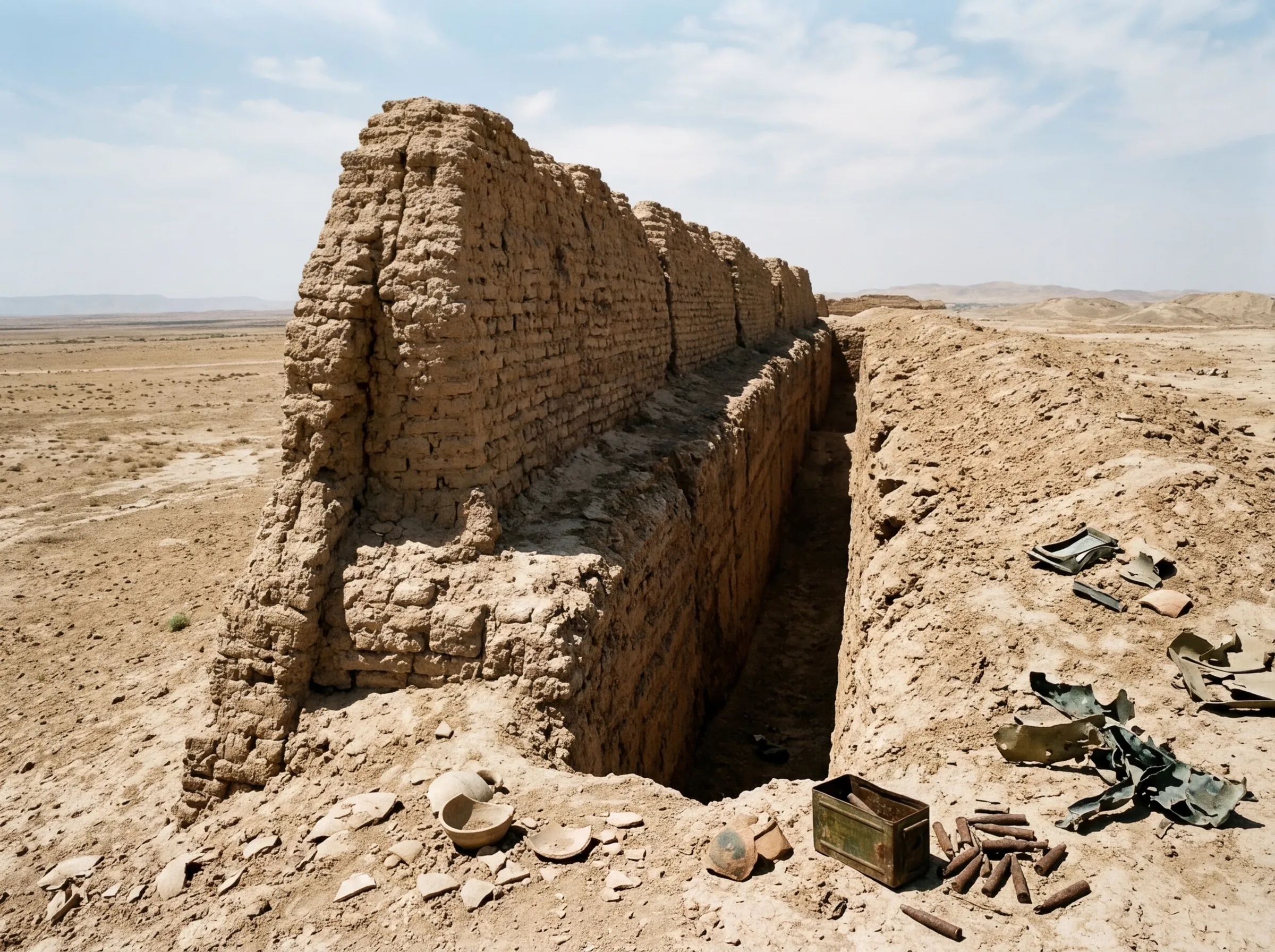
Ali Wehayib Abdul Abbas, who served as a conscript at the site, later became its guardian. "The army engineers arrived in 1984, and cut the ancient walls and dug their trenches," he told researchers. The Iranians never quite reached the site, halted at the Majnoon oil field during their closest offensive in 1987. Subsequent wars and instability kept archaeologists away for decades more.
The breakthrough came in 2013. British archaeologists Jane Moon, Robert Killick, and Stuart Campbell were working near the ancient city of Ur when the director of the Basra Antiquities and Cultural Heritage Inspection asked if they would like to visit another site. They traveled the 50 kilometers from Basra in a tight convoy of heavily armored vehicles. On arrival, they confirmed what Hansman had suspected half a century earlier: the vast, mostly flat ruins at Jebel Khayyaber were the remains of Alexander's city. Professor Hauser joined the project in 2016, and the Charax Spasinou Project began systematic fieldwork under extraordinary conditions, with soldiers or police officers present at all times and summer temperatures exceeding 49 degrees Celsius.
What the Geophysics Revealed
Because the city was abandoned rather than built over by subsequent civilizations, its layout is preserved just beneath the surface. The research team walked more than 500 kilometers on foot during surface surveys, documenting dense scatters of pottery, brick fragments, and industrial debris. Cesium magnetometers, instruments sensitive enough to detect buried walls by measuring picotesla-level variations in the earth's magnetic field, mapped the city's structure without a single excavation trench.
The results surprised even the team that found them. "The quality of the geophysical evidence is absolutely stunning," Hauser said. "The preservation of buildings is surprisingly good."
Four distinct civic zones emerged from the data. A residential district laid out on a grid plan contained housing blocks measuring 185 by 85 meters, among the largest residential insulae found anywhere in the ancient world. At least two large public buildings and temple complexes appeared within walled precincts. A river port district contained workshops with kilns and smelting installations. And an extensive canal and irrigation system connected the city to what was once the Tigris riverfront and harbor.
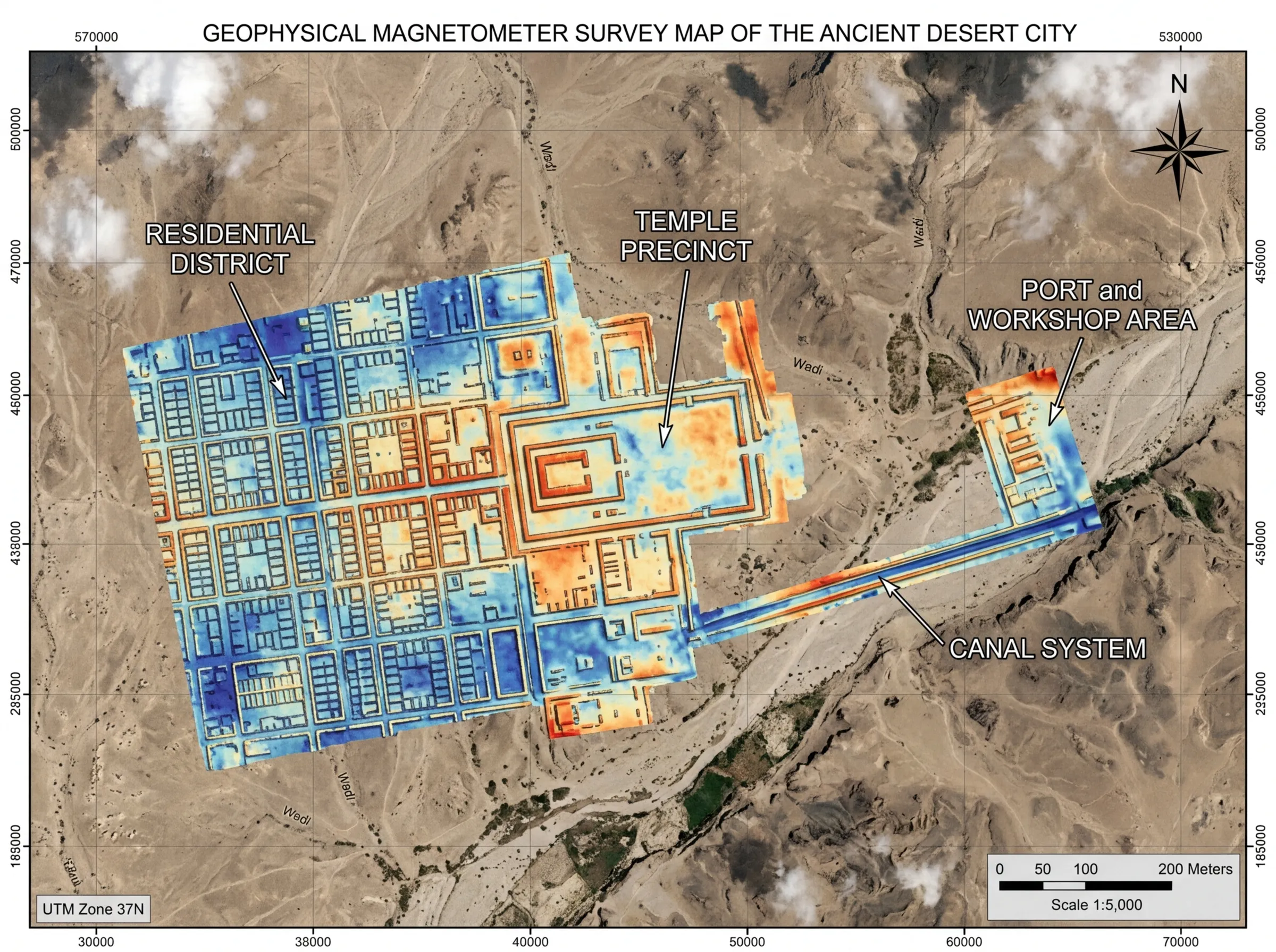
"The size of the city blocks is extraordinary," Hauser noted. "It surpasses even those of the major capitals of the time, like Seleucia on the Tigris or Alexandria on the Nile." The city was not a frontier outpost. It was a metropolis, purpose-built for commerce on a scale that matched the ambitions of the man who commissioned it.
A Trade Superpower That Connected Three Continents
For more than 550 years, from roughly 300 BC to 300 CE, the city functioned as the gateway where goods from the East entered Mesopotamia and the Mediterranean world. Indian spices, exotic woods, semi-precious stones, and likely Chinese silk arrived through the Persian Gulf. The Roman naturalist Pliny the Elder called it "a centre of trade for rare perfumes" and noted its pearl-diving industry. The Greek geographer Strabo described it as an emporium. Palmyran merchants maintained a permanent trading station there, documented in numerous inscriptions that trace the flow of caravans between the Gulf and the Mediterranean.
The city's most famous citizen was Isidore of Charax, who authored the Mansiones Parthicae (Parthian Stations), a treatise documenting trade routes across the entire Parthian Empire. His work remains one of the primary sources for understanding overland commerce in the ancient Near East, a kind of early road atlas for merchants and diplomats.
The city's eventual decline was not military but geological. Pliny recorded the problem with growing alarm. At the city's founding, the Persian Gulf coastline lay roughly two kilometers away. By the first century BC, sedimentation had pushed it 80 kilometers distant. Today, the Gulf is nearly 180 kilometers south of the site. The Tigris itself shifted westward, cutting off the harbor that gave the city its purpose. By the third century CE, the port that had once connected ancient civilizations across vast distances was stranded in open desert.
The city did not vanish all at once. Coins continued to be minted there through the Sasanian Empire and into the Islamic period, as late as 715 AD. But the economic center of gravity had shifted to Basra, 40 kilometers to the south, and the ramparts of Alexander's last city slowly dissolved into the alluvial plain.
Alexander's Network of Cities
Alexandria on the Tigris was one of approximately 20 to 30 cities Alexander founded across his empire, stretching from Egypt to Central Asia. The most famous, Alexandria on the Nile, remains a major city today. Others have been identified at varying levels of certainty. Alexandria Arachosia became modern Kandahar, Afghanistan (the name "Kandahar" is a corruption of "Alexandria"). Alexandria Eschate, "the Furthest," survives as Khujand, Tajikistan, at the northeastern edge of Alexander's conquests. Alexandria Bucephalus, named after his beloved horse, stood near the modern city of Jhelum in Pakistan.
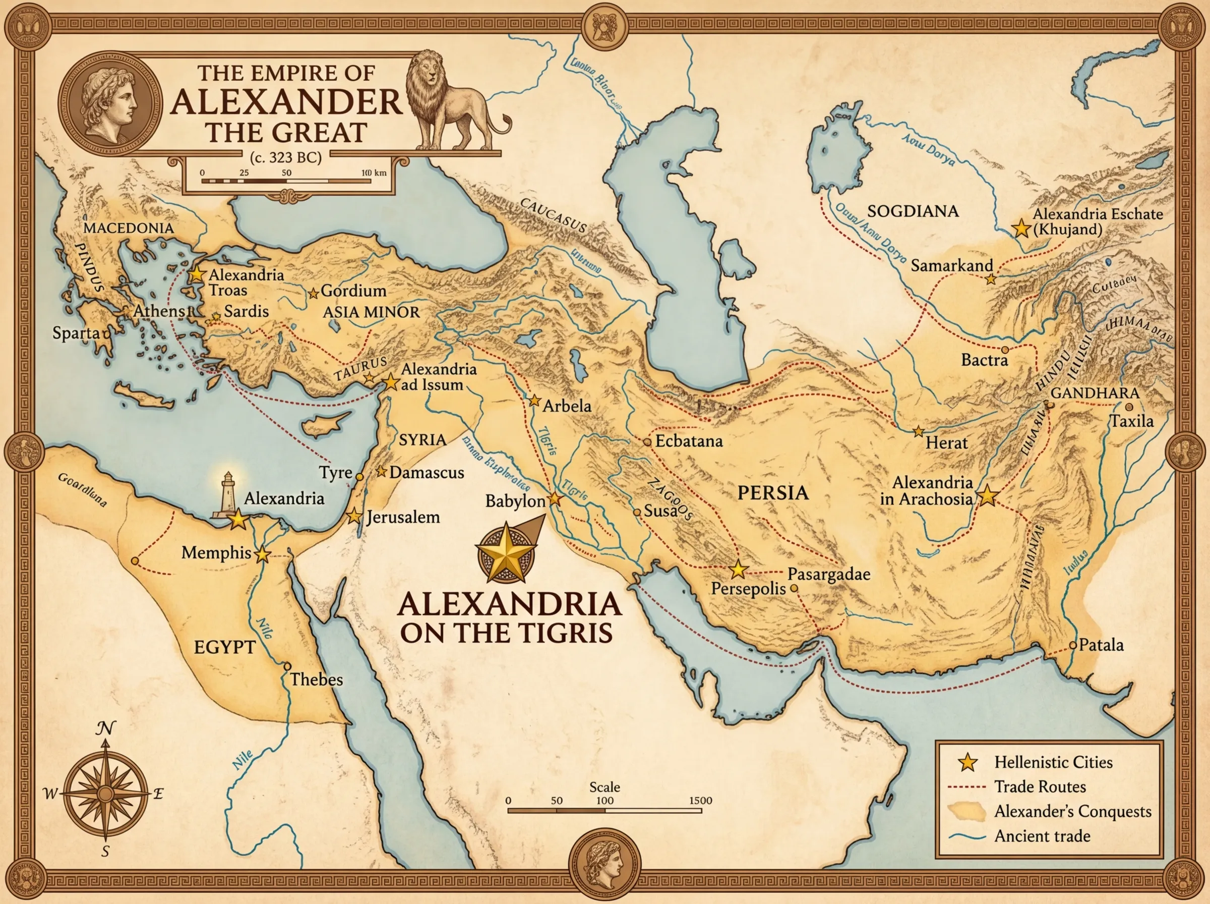
What distinguishes the Tigris site from most of these others is preservation. Most Alexandrias were either continuously occupied for millennia (burying the original layers under centuries of later construction) or thoroughly plundered. The city at Jebel Khayyaber was abandoned and left alone, aside from the Iran-Iraq War damage. Its walls sit immediately beneath the surface. Its street grid is intact. Its harbor basins, temple precincts, and workshop districts can be mapped from above without turning a single shovel of earth. It is, as the research team described it, a time capsule.
It also fills a gap in scholarship that has persisted for centuries. "There is not a single useful summary of its history, structure and culture," Hauser has noted about the Parthian period, the era when Charax Spasinou reached its commercial zenith. The site offers the rare chance to reconstruct a complete picture of a civilization that has been poorly understood precisely because so few of its cities have been excavated.
War Shuts It Down Again
On March 25, 2026, The Art Newspaper reported that the planned geophysical campaign at Jebel Khayyaber has been postponed due to the current conflict between the United States, Israel, and Iran. Iraqi airspace is closed. At least 82 people have been killed in Iraq. The 71st Rencontre Assyriologique Internationale, an annual gathering of scholars who study ancient Mesopotamia, has been cancelled.
Hauser called the situation "a complete catastrophe" in many respects. "The Iraqi airspace is closed and there is hardly any other way to enter or leave the country," he told the newspaper. "We were planning a campaign of geophysical work which had to be postponed. If we are lucky, we can apply again for autumn."
There is a bitter symmetry to it. The city was founded by a conqueror. It was fortified and scarred by twentieth-century war. It was finally confirmed by archaeologists who arrived in armored vehicles. And now, with its secrets barely beginning to surface, it has been sealed off by conflict once more. The mudbrick walls that have waited 2,300 years will have to wait a little longer.
What This Means
Alexander the Great understood something that modern empires still struggle with: military conquest without commercial infrastructure does not hold. He did not just march armies across three continents. He planted cities at the critical junctions of trade, creating a network designed to outlast him. The city at the head of the Persian Gulf was the commercial linchpin of that network, positioned to channel the wealth of India and Central Asia into the Mediterranean world.
That it took until 2026 to confirm its location says less about the city's obscurity than about the relentless instability of the region where it sits. Southern Iraq, 15 kilometers from the Iranian border, has been a conflict zone for most of the last century. The archaeologists who finally reached the site did so in armored vehicles, worked under armed guard in 49-degree heat, and are now waiting out yet another war. The city's preservation is remarkable. So is the fact that its excavation depends entirely on the same geopolitical forces that buried it in the first place.
What the geophysics have already revealed is enough to reshape our understanding of Hellenistic urbanism and ancient global commerce. The housing blocks are larger than those at Seleucia. The port infrastructure suggests a volume of trade that written sources only hinted at. And the site has barely been touched. When the dig resumes, if it resumes, the team expects to complete the full geophysical map of an entire ancient city, a feat nearly impossible at sites that have been continuously occupied. The city Alexander built to connect his empire is, for now, still waiting to be fully read.
Sources
- University of Konstanz / EurekAlert: "Alexandria on the Tigris: a forgotten and rediscovered metropolis" - Official press release with Professor Hauser's findings and quotes
- Archaeology Magazine: "New Research Confirms Location of Lost City Founded by Alexander the Great" - Detailed coverage of the confirmation and geophysical evidence
- The Art Newspaper: "Excavations at Alexander the Great's rediscovered city in Iraq postponed due to war" - March 2026 postponement and Hauser's "complete catastrophe" quote
- ARTnews: "Researchers Confirm Location of Lost City of Alexandria on the Tigris" - Discovery overview and historical context
- Voices for Iraq: "On the Iraq border, archaeological digs are a minefield" - First-hand account of Iran-Iraq War damage at the site and Ali Wehayib Abdul Abbas's testimony